


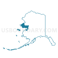
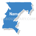
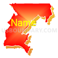
White Mountain Precinct, Nome Census Area, Alaska
About
Outline

Summary
| Unique Area Identifier | 523471 |
| Name | White Mountain Precinct |
| County | Nome Census Area |
| State | Alaska |
| Area (square miles) | 2,672.41 |
| Land Area (square miles) | 2,512.44 |
| Water Area (square miles) | 159.97 |
| % of Land Area | 94.01 |
| % of Water Area | 5.99 |
| Latitude of the Internal Point | 64.93030710 |
| Longtitude of the Internal Point | -163.38024120 |
Maps


Graphs
Select a template below for downloading or customizing gragh for White Mountain Precinct, Nome Census Area, Alaska


Neighbors
Neighoring Voting District (by Name) Neighboring Voting District on the Map
- Deering Precinct, Northwest Arctic Borough, AK
- Golovin Precinct, Nome Census Area, AK
- Koyuk Precinct, Nome Census Area, AK
- Nome No. 2 Precinct, Nome Census Area, AK
- Teller Precinct, Nome Census Area, AK
Top 10 Neighboring County Subdivision (by Population) Neighboring County Subdivision on the Map
- Nome census subarea, Nome Census Area, AK (9,492)
- Northwest Arctic census subarea, Northwest Arctic Borough, AK (7,523)